The concept of Civil 3D sites is something brand new to most users. Land Desktop didn't have anything similar.
I am going to do my best to explain my understanding of sites (from my own trial and error so if I say something in error, please let me know) and how I typically leverage them. I'd love hear what you think.
Also reference my blog post "Parcel Rules Explained"
Geometry that lives on the same site reacts to each other.
"Geometry" includes:
ALIGNMENTS---PARCELS---GRADING GROUPS---FEATURE LINES
Geometry that lives on separate sites does not react to each other.
Here is a simple illustration:
"SAME SITE" GEOMETRY
A parcel is created on Site 1. An Alignment is created also on Site 1. The parcel reacts to the alignment by treating the alignment as a parcel segment, and now there are two parcels.

"DIFFERENT SITE" GEOMETRY
A parcel is created on Site 1. An Alignment is created on Site 2. These elements do not react to each other.

Now let's think of this in practical terms.
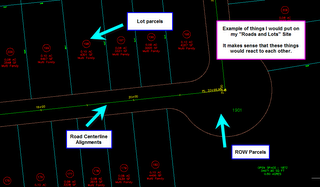
Think of geometry that makes sense to react to each other...
A road centerline, a ROW parcel and subdivision lots would make sense. We build the ROW based on the centerline and we use slide angle create to lay in our lots. These elements need each other to be defined properly. Therefore, they should all be on the same site.
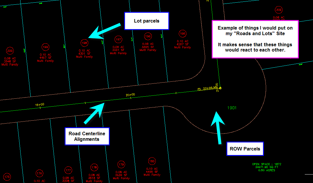
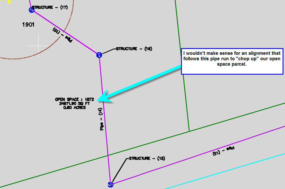
Now, think of geometry that absolutely should not react to each other. How about an offsite sewer line. You define an alignment that follows the path of a pipe run. Would it make sense if that alignment sliced a platted parcel in half? Probably not.


You can find your list of Sites on the Prospector tab (just ask General Toolspace where to find them). Right click on the word "Sites" to make a new one.

So next time you make an alignment to follow that offsite sewer- choose the right site.

What do I use all of these sites for? Here are some ideas:
1) Boundary- I like to keep an intact survey boundary so that it can be studied and labeled intact. Subdividing the site will chop up my boundary, so I preserve a copy on its own site. It is usually the only thing on that site.
2) BRL- I make parcels out of building restriction lines. This assists me in some area calcs, CAD standards enforcement and labeling.
3) Grading- I personally hate that feature lines and grading interacts with platted lots if on the same site, so I just make a grading site and keep them away from any parcels.
4) Roads and Lots- This is the "meat". Road centerlines, ROW, platted subdivision lots. I keep grading AWAY from this one, and special alignments for pipe runs AWAY.
5) Sanitary Sewers- A MUST-HAVE site if you have to profile your sanitary sewers along their own alignments (as opposed to showing them on the road centerline profile) such as offsite sewers, sewers that cut through lots, etc.
6) Storm Sewers - MUST-HAVE site if you have to profile your storm sewers along their own alignments (as opposed to showing them on the road centerline profile) such as offsite sewers, sewers that cut through lots, etc.
7) Stormwater Management- A nifty site that you could also handle in its own drawing. I use parcels for subcatchment boundaries and alignmnets for TC paths. This gives me a chance to take advantage of special labeling, area tables and more. To learn more about this, come to Autodesk University and I will show you my tricks.
Alternatively, you can handle the geometry separation with an actual separate drawing. This prevents accidentally putting things on the wrong site, reduces user confusion and protects especially fragile geometry. I personally like the idea of a "Roads and Lots" Baseplan. Keep in mind that parcels cannot be "data shared", so this would strictly be a visual connection, but that is what I like about it. It keeps me from accidentally grip editing a parcel or putting a pipe run alignment on the wrong site.

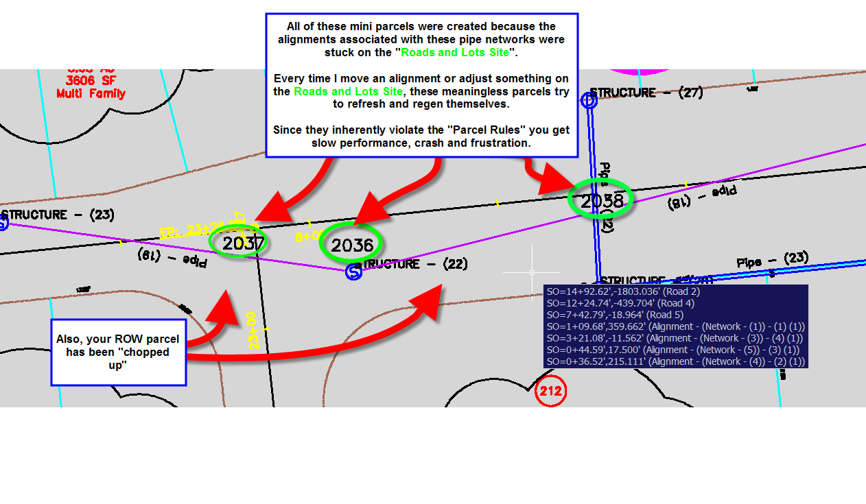
Drawing stability issues CAN stem from not using your sites properly.
I have seen this more than once. Your average Civil 3D intro class does not spend any time discussing sites. So, our first project, we just start working away. Before you know it, we have all kinds of geometry trying to "define" itself based on things that just don't make topologic sense (see also "Parcel Rules Explained"
for more info here)
This causes CRASH after CRASH on simple things. Here is an example of what might be going on:

I am going to do my best to explain my understanding of sites (from my own trial and error so if I say something in error, please let me know) and how I typically leverage them. I'd love hear what you think.
Also reference my blog post "Parcel Rules Explained"
Geometry that lives on the same site reacts to each other.
"Geometry" includes:
ALIGNMENTS---PARCELS---GRADING GROUPS---FEATURE LINES
Geometry that lives on separate sites does not react to each other.
Here is a simple illustration:
"SAME SITE" GEOMETRY
A parcel is created on Site 1. An Alignment is created also on Site 1. The parcel reacts to the alignment by treating the alignment as a parcel segment, and now there are two parcels.

"DIFFERENT SITE" GEOMETRY
A parcel is created on Site 1. An Alignment is created on Site 2. These elements do not react to each other.

Now let's think of this in practical terms.
Think of geometry that makes sense to react to each other...
A road centerline, a ROW parcel and subdivision lots would make sense. We build the ROW based on the centerline and we use slide angle create to lay in our lots. These elements need each other to be defined properly. Therefore, they should all be on the same site.
Now, think of geometry that absolutely should not react to each other. How about an offsite sewer line. You define an alignment that follows the path of a pipe run. Would it make sense if that alignment sliced a platted parcel in half? Probably not.
You can find your list of Sites on the Prospector tab (just ask General Toolspace where to find them). Right click on the word "Sites" to make a new one.

So next time you make an alignment to follow that offsite sewer- choose the right site.

What do I use all of these sites for? Here are some ideas:
1) Boundary- I like to keep an intact survey boundary so that it can be studied and labeled intact. Subdividing the site will chop up my boundary, so I preserve a copy on its own site. It is usually the only thing on that site.
2) BRL- I make parcels out of building restriction lines. This assists me in some area calcs, CAD standards enforcement and labeling.
3) Grading- I personally hate that feature lines and grading interacts with platted lots if on the same site, so I just make a grading site and keep them away from any parcels.
4) Roads and Lots- This is the "meat". Road centerlines, ROW, platted subdivision lots. I keep grading AWAY from this one, and special alignments for pipe runs AWAY.
5) Sanitary Sewers- A MUST-HAVE site if you have to profile your sanitary sewers along their own alignments (as opposed to showing them on the road centerline profile) such as offsite sewers, sewers that cut through lots, etc.
6) Storm Sewers - MUST-HAVE site if you have to profile your storm sewers along their own alignments (as opposed to showing them on the road centerline profile) such as offsite sewers, sewers that cut through lots, etc.
7) Stormwater Management- A nifty site that you could also handle in its own drawing. I use parcels for subcatchment boundaries and alignmnets for TC paths. This gives me a chance to take advantage of special labeling, area tables and more. To learn more about this, come to Autodesk University and I will show you my tricks.
Alternatively, you can handle the geometry separation with an actual separate drawing. This prevents accidentally putting things on the wrong site, reduces user confusion and protects especially fragile geometry. I personally like the idea of a "Roads and Lots" Baseplan. Keep in mind that parcels cannot be "data shared", so this would strictly be a visual connection, but that is what I like about it. It keeps me from accidentally grip editing a parcel or putting a pipe run alignment on the wrong site.

Drawing stability issues CAN stem from not using your sites properly.
I have seen this more than once. Your average Civil 3D intro class does not spend any time discussing sites. So, our first project, we just start working away. Before you know it, we have all kinds of geometry trying to "define" itself based on things that just don't make topologic sense (see also "Parcel Rules Explained"
for more info here)
This causes CRASH after CRASH on simple things. Here is an example of what might be going on:


1 Comment:
Enlightening post... have you found that multiple grading groups within the same site adversely affect C3D stability also?
Post a Comment